Saturday, December 09, 2006

THIS IS NOT A FALSE ALARM/THIS IS NOT A TEST

I have read a number of things this week, some from New Orleans
bloggers and some from other sources, that has brought to my
attention something I knew was going to happen one day:

Insurance companies will force us to change
how and where we live.

But I really didn't expect one of the first places that it would
happen is the place I grew up.

To give you some background, I have been rubbing shoulders
with insurance company types since I was finishing up my PhD.
I've had headhunters from USF&G (now part of St Paul Travelers)
and RMS talk to me about job possibilities. And I've sat
through many many talks on natural disaster PML (Probable
Maximum Loss). I know the tail of the distribution that keeps
the insurance types awake at night.

I understand why no one in New Orleans likes the RMS study
on flood risk. I also read the study (twice) and have a very
good idea how they came up with their numbers. And after
I stopped cursing and crying I have to admit that they are
basically right. If New Orleans and south Louisiana follow
"business as usual" (preparing for the last hurricane, not the
next), something worse than Katrina happens the next time.

But it's not just New Orleans that has to worry about this.
From the RMS study:

Then there is a much longer list of cities at risk from rising
sea levels and more intense storms, including cities all along
the U.S. Atlantic and Gulf coasts.

One of those places is here: Charleston, South Carolina.
Barre Street, on the west side of the peninsula, wasn't
built below high tide. But it floods during a spring tide - I
saw water in the street there just yesterday (and no, it
wasn't raining). The problem is the Atlantic Ocean is a
foot higher in Charleston harbor than it was 100 years
ago (you can see Charleston tide gauge data here).
Students in one my classes this semester also looked at
the tide gauge data up and down the coast and it's the
same story from Delaware down to Florida. Sea level
rise isn't a prediction, it's a measurement.

And for that reason, the insurance problem New Orleans
is facing is also happening to everyone else on the coast.
I'm sorry folks but it's time to stop pretending that
climate change is something that might happen and
start acting like it is happening. Cause it is. Sorry
Dangerblond, but you're going to have to give up the
Exploder for something more fuel efficient (and
hopefully less flammable).

And since Neil Peart (whom I've stolen the title of
this post from) has something hopeful to say in
even his most depressing songs, I'll end with the
finale of "Red Tide":


Now's the time to turn the tide
Now's the time to fight
Let us not go gently
To the endless winter night
Now's the time to make the time
While hope is still in sight
Let us not go gently
To the endless winter night

Tuesday, August 29, 2006

Remember


I remember.

I remember seeing the satellite images of Hurricane Katrina when it
was a Category 5 in the Gulf of Mexico and thinking how beautiful it
was. And how much that frightened me.

I remember thanking God when I couldn't reach my family at home
but instead on my brother's cellphone as they were driving north
through Alexandria.

I remember showing the radar loops from Slidell to my classes the
morning Katrina came ashore, describing how its path would spare
New Orleans the worst but increase the impact on the Mississippi
Gulf Coast.

I remember going to bed that night thinking the only breached levee
was along the Industrial Canal leading into the Lower Ninth Ward.

I remembered that my Dad was among those who rescued people
from the Lower Ninth Ward after Hurricane Betsy in 1965.

I remember my horror at seeing the first pictures of Lake Ponchatrain
pouring through the breach in the 17th Street Canal.

And my growing fear as my all too well-trained brain brought up a
DEM of New Orleans and mapped the flood in my mind.

I remember much more from the days and weeks and months that
followed, the inside of my cousins's flooded Lakeview home, the miles
and miles of desolation, the weight of the moldy sheetrock and
cabinets my brother and I tore out of my parent's home.

I remember.

Sunday, August 13, 2006

Mississippi River: Ally not Enemy

In the past year I have been learning (and in some cases relearning)
more about the Mississippi River and its contribution to the state of
Louisiana and the USA in general. I have read translations of the
reports from deSoto's expedition from the flood of 1543 and reviewed
the founding of New Orleans in 1718. I've updated my knowledge of
the oil-bearing strata that lies under Louisiana and its offshore. I've
read piles of papers and reports on subsidence and also how the river
built south Louisiana in the last 5000 years. Last summer (before
Katrina) I reread John Barry's "Rising Tide" in preparation for a
lecture on the 1927 flood in the Natural Hazards course I teach. I
am probably as well informed on this subject as I have ever been
in my entire life.

And what keeps hitting me is how much the Mississippi River
has contributed to Louisiana and the USA. In some ways it
defines us. It's alluvial soils feed millions here and its water brings
food to millions more across the world. The growth of the delta has
not only created much of south Louisiana but the overlapping marsh,
river and marine deposits atop a semi-fluid salt layer created a near
perfect superposition of petroleum source/reservoir rocks and
wonderfully complex traps to hold them in (yeah, I have a thing for
3D seismic). The marsh of delta nourishes an amazingly fertile
fishery. What not to like about the Mississippi River?

And yet we hide it behind levees and let its waters reach the sea in
only a few restricted places. We treat it like a wild beast that needs
to be tamed and kept in a cage. We send most of its life-bearing
water and silt into the deep Gulf of Mexico.

We need to start treating the Mississippi River as a friend and ally,
as one of the greatest gifts God has given to the State of Louisiana
and the nation as a whole. Yes, it is a wild thing and needs to be
respected as such. But we need to restore as many of its natural
rhythms as possible and see to it that it works in our favor as it
should. Some people will have to give up where they live so the river
can flow there again. Some will have to deal with uncertainity, not
knowing what the delta will look like after a big spring flood. But
we'll gain far more than we will lose.

Tuesday, July 18, 2006

Levees in distress


One of the more worrisome things I read in the online Times-Picayune (http://www.nola.com/) in the months following Hurricane Katrina was the discovery that, in addition to the failed levees, there were several sections that were "distressed". The most disturbing of these to me was one located on the west (Metairie) side of the 17st Canal; i.e., on the side of the canal where my parents and brother and other family and several hundred thousand other people live. So when I visited in December 2005 I took a day off from replacing sheetrock in my parents flooded home (yes Virginia, parts of Metairie flooded too) and walked the west (Metairie) side floodwall on the 17st Canal.

The photos above show small but significant displacements between two sections of floodwall on the west (Metairie) side of the canal. They don't look like much, but they are larger than the gaps between any of the other floodwall sections. John Rogers, one of the members of NSF's Independent Levee Investigation Team, found the same section but was smart enough to get on top of the floodwall to take his picture. I guess that's why he's the earthen dam/levee expert and I'm just an earthquake chaser.

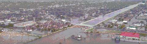
Why does this matter? Two reasons, one fortunately hypothetical and the other very real. First, if the west (Metairie) side levee of the 17th Street Canal had given way before the east (Orleans) side, a vastly larger part of the New Orleans metro areas floods. Orleans Parish's fate is already sealed by the London Avenue levee breaches, but a breach on the west (Metairie) side of the 17th Street Canal floods all of the East Bank of Jefferson Parish. More people die, more homes and businesses are destroyed, and basically New Orleans is even more screwed than it actually was. More people need to rescued, but staging areas like Zephyr Field and triage/evacuation centers like the Louis Armstrong Airport are under water. Think of it this way: more people need help but help has alot harder time getting to them. That ~10,000 dead number starts to look more like a realistic estimate under those conditions.

The second thing that concerns me is this: Do we know where all the other weak/distressed levee sections are? Some, like near Lake Vista Drive in Kenner, are known weak points and are getting some attention. But are there others? What tale do the rest of the geotechnical boreholes tell? Are there enough of them to really characterize the geology beneath the levee system?

Yeah, I know, I am probably overdoing it. But I never expected that a category 3 hurricane would produce seven major levee failures. One would have been bad and two disasterous. Seven? Ouch!

Color Me Pissed

Ok, I was hoping to get in a few Katrina related posts before something like this happened. From The Guardian Unlimited UK (http://www.guardian.co.uk/indonesia/Story/0,,1823219,00.html
regarding the earthquake and tsunami in Java:


Officials failed to pass on tsunami warning

The government's
science and technology minister, Kusmayanto
Kadiman, confirmed today that Indonesia had received bulletins
from the Pacific Tsunami Warning Centre in Hawaii and Japan's
meteorological agency after the quake, but "we did not announce
them. If it [the tsunami] did not occur, what would have
happened?" he said in Jakarta.

What the fuck? Why even put together a tsunami warning system unless you are going to use it? Sorry Kusmayanto Kadiman but 300+ lives are more important than Covering Your Ass. What makes me doubly furious is I personally know a now retired USGS seismologist who was standing by helpless on Dec. 26, 2004, unable to contact anyone on South Asia because the communication lines weren't set up. You would think Indonesian officials would have bent over backwards to get the warning out - instead this happens.

I need a beer.

Saturday, July 15, 2006

Old Hammond Highway Bridge

What's the Old Hammond Highway Bridge? It's the bridge that crosses the 17th Street Canal at Lake Ponchatrain in New Orleans. It's also near the site of one of levee breaches that flooded the city of New Orleans in the aftermath of Hurricane Katrina.


Why the Old Hammond Highway Bridge? That's a bit of a story. First, I was born and raised in Greater New Orleans. My favorite West End seafood restaurant, Brunings, was near the Old Hammond Highway Bridge. My parents favorite after church breakfast place, Russell's Marina, is near the Old Hammond Highway Bridge. One of my cousin's had a house in Lakeview, not far from the Old Hammond Highway Bridge. I have driven across that bridge so many times I can't count.

And as I grew up and learned more about the history and geology of New Orleans, as I grew professionally and learned how natural hazards impact people and the structures they rely on, every time I drove across the Old Hammond Highway Bridge I looked at how the water in the 17th Street Canal was above the level of the ground on both sides. And I said to myself that if those levees and floodwalls ever failed there'd be hell to pay.

And then I woke up on the day after Hurricane Katrina passed New Orleans, thinking my hometown had dogged another bullet, and found one of my worst nightmares coming true on national TV.

Enough said on my first post. There's alot more to come.

Testing

This is a test. I hate tests.